

Administrative information
The forest to which this development plan relates is Forestry Management Unit (UFA) no. 10-012, allocated to the SEFAC SA Group by the Interministerial Logging Permit Committee at its meeting held in November 1997. UFA 10-012 is situated administratively in the East Province of Cameroon, Boumba and NGoko Département, specifically in Moloundou Arrondissement, Salapoumbé District.
Definition of boundaries and geographical location
Forestry Management Unit 10-012, shown on the Moloundou 1:200,000 ISH map, reference sheet NA-33-XVI, lies between latitudes 2°33 and 2°38 North and longitudes 15°39 and 16°08 East (Figure 1).
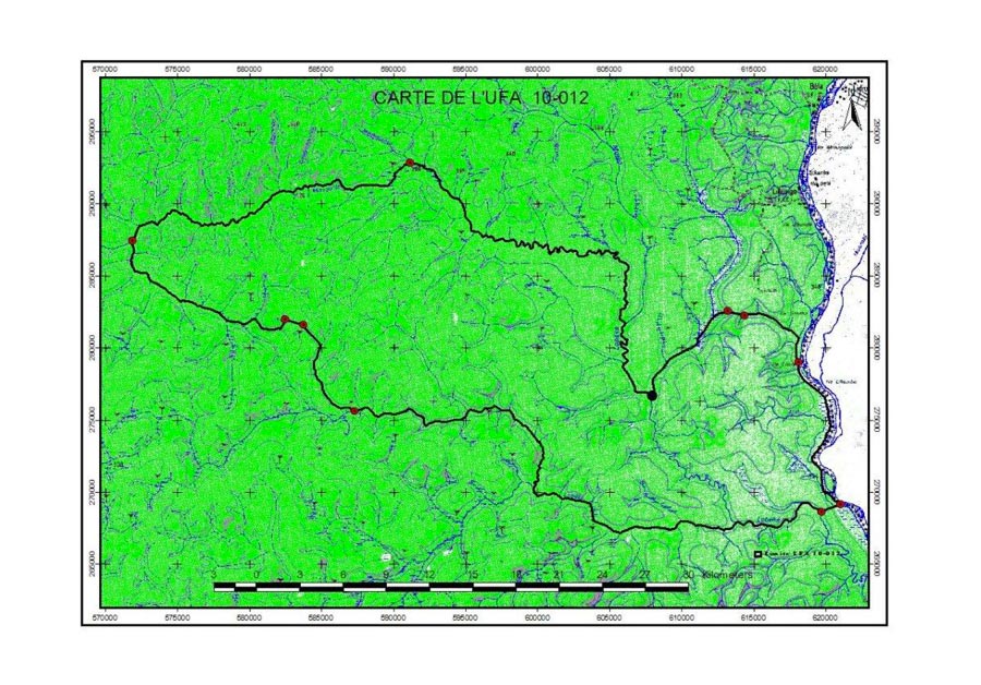
Figure 1 – Map showing location of UFA 10-012
The boundaries of this UFA, as proposed by the classification, are described as follows (Figure 2):
Reference point R is located at the confluence of the River Lobéké and the River [Sangha];
- From point R, follow the Sangha upstream for 5.5 km to reach point A, called the base point, located at the confluence of the Sangha and an unnamed watercourse.
To the south:
- From point A, called the base point, follow that unnamed watercourse upstream for 0.4 km to reach point B, located on the watercourse;
- From point B, follow a bearing of 249° for 1 km to reach point C, located at the River Lobéké;
- From point C, follow the River Lobéké upstream for 45 km to reach point D, located at the confluence of the R. Lobéké and an unnamed tributary, equivalent to point T of UFA 10-011.
To the west:
- From point D, follow that unnamed tributary upstream for 8.5 km to reach point E[. From point E follow] a bearing of 272° for 0.5 km to reach point F, located at the source of an unnamed tributary of the River Monguélé, equivalent to point Q of UFA 10-011;
- From point F, follow that unnamed tributary downstream for 16.5 km to reach point G, located at the confluence of the R. Monguélé, and equivalent to point T of UFA 10-010 and point P of UFA 10-011.
To the north:
- From point G, follow the River Monguelé downstream for 62 km to reach point H, located at the confluence of the R. Lobéké and the R. Mokalabo, equivalent to point U of UFA 10-010;
- From point H, follow the River Mokalabo upstream for 7.2 km to reach point I, located at the confluence of the R. Mokalabo and an unnamed watercourse, equivalent to point V of UFA 10-010.
To the east:
- From point I, follow an unnamed watercourse upstream for 1.4 km to reach point J at its source;
- From point J, follow a bearing of 100° for 1.2 km to reach point K at a unnamed watercourse;
- From point K, follow that watercourse downstream for 6.0 km to reach point L, located at the confluence of the R. Sangha and that watercourse; from point L, follow the Sangha downstream for 12 km to return to point A, called the base point.
Ecological factors
Topography
The Moloundou Arrondissement, especially the area of UFA 10-012, mainly features low-relief terrain. The terrain is flat, with the highest points at an altitude of around 500 m. It presents as a peneplain which is uneven in places, supporting thick forest growth.
Pedology
UFA 10-012 mainly lies on lateritic soils resulting from the breakdown of metamorphic rocks consisting of sandstone and shale during the Precambrian Era.
These soils are nutrient-poor, acidic and fragile. The most widespread (orthic) soils are mainly covered with forest on dry land. They are sometimes several metres thick, and are red, clayey, very porous and loose. They are permeable, with little humus.
The “aliatic” soils, always found on dry land, differ from the former in terms of their structure, which is sometimes phaneric or very fine. Alluvial soils are found in the low-lying areas, and hydromorphic soils in the marshes.
Hydrography
The hydrographic network in UFA 10-012 is very extensive. This network belongs to the Congo Basin. The forest is watered by several rivers. They include the Goboumo, Lobéké and Mokalabo rivers, all of which flow into the Sangha, which forms the natural western boundary of the UFA. Other unnamed watercourses also flow through the UFA.