

Administrative information
Forestry concession no. 1053 is located on permanent State forestry land. It consists of Forestry Management Unit (UFA) 10-010 specified in the South Cameroon zoning map (MINEF/ONADEF, 1995a and 1995b). This UFA was granted to SEFAC by Temporary Logging Agreement no. 0836\CPE\MINEF\CAB on 4 October 2001. It is located in the East province, Boumba and Ngoko Department, specifically in the Moloundou Arrondissement.
Definition of boundaries and geographical location
The area of UFA 10-010 is estimated at 66,688 ha (sixty-six thousand six hundred and eighty-eight hectares) in the Area Measurement Certificate drawn up by the Land Registry Office of BOUMBA and NGOKO Département.
The UFA is situated between latitudes 2º 30′ 08” and 2º 47′ 14” North and longitudes 15º 36′ 00” and 16º 01′ 10” East on the MOLOUNDOU 1:200,000 cartographic map (NA-33-XVI) (Figure 1).
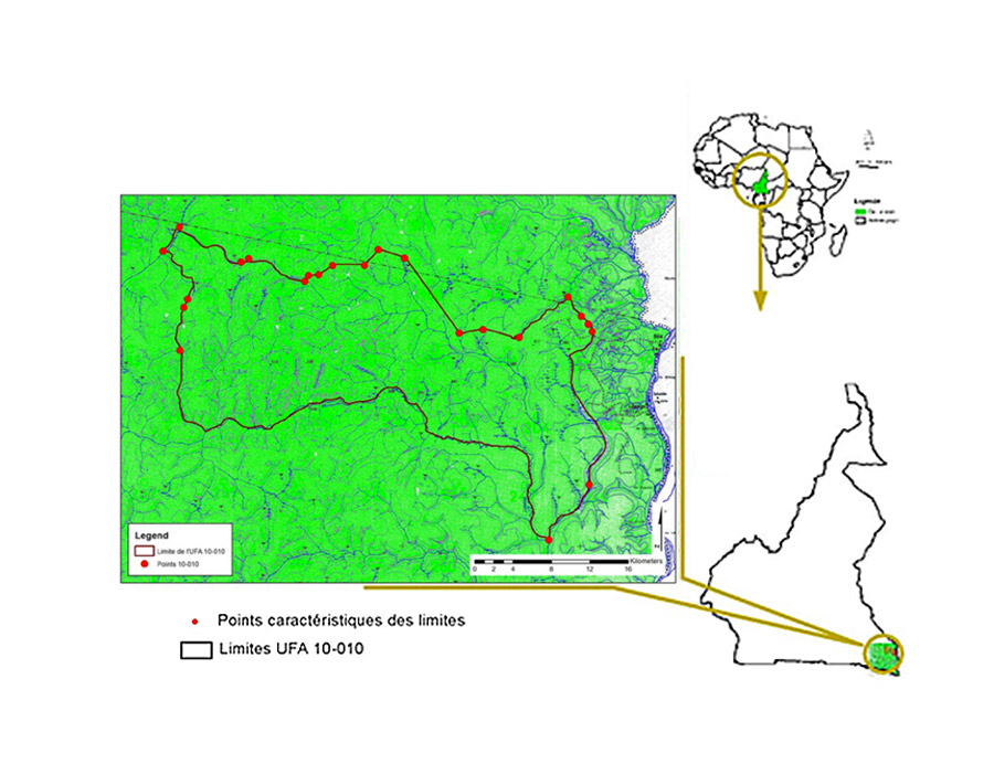
Figure 1 – Map showing location of UFA 10-010
It is bounded:
- to the north by UFA 10-008;
- to the south by UFA 10-012;
- to the west by UFA 10-007 and 10-011;
- to the east by a tributary of the River Lobéké which separates the forest from an agroforestry area near the village of Libongo.
According to the Area Measurement Certificate drawn up by the Département Land Registry office in Yokadouma, UFA 10-010 covers an area of 72,727 ha (seventy-two thousand seven hundred and twenty seven hectares), currently being classified by the Prime Minister’s Office. These boundaries are described in Figure 2.
Point A, called the base point, is located at the confluence of the Goboumo watercourse and one of its unnamed tributaries, at the level of the international border with the Central African Republic, equivalent to point A8 of UFA 10-009.
To the south:
- From point A, follow the unnamed tributary upstream for 4.5 km to reach point B, located at a spring, equivalent to point A7 of UFA 10-009;
- From point B, follow a bearing of 261° for 0.5 km to reach point C, located at the source of an unnamed watercourse, equivalent to point A6 of UFA 10-009;
- From point C, follow that watercourse downstream for 1.5 km to reach point C, located at a confluence, equivalent to point A5 of UFA 10-009;
- From point C, follow the other branch upstream for 7.5 km to reach point D, located at a small confluence, equivalent to point A4 of UFA 10-009;
- From point D, follow a bearing of 278° for 4.8 km to reach point E, equivalent to point A3 of UFA 10-009;
- From point E, follow a bearing of 274° for 1.9 km to reach point F, equivalent to point A2 of UFA 10-009;
- From point F, follow a bearing of 253° for 3.2 km to reach point G, equivalent to point A1 of UFA 10-009;
- From point G, follow a bearing of 348° for 1.7 km to reach point H, equivalent to point Z of UFA 10-009;
- From point H, follow a bearing of 295° for 0.8 km to reach point I, equivalent to point Y of UFA 10-009;
- From point I, follow a bearing of 235° for 2 km to reach point J, equivalent to point X of UFA 10-009;
- From point J, follow a bearing of 248° for 3 km to reach point K, equivalent to point W of UFA 10-009;
- From point K, follow a bearing of 264° for 1.9 km to reach point L, equivalent to point V of UFA 10-009;
- From point L, follow a bearing of 27º for 1.1 km to reach point M, equivalent to point U of UFA 10-009;
- From point M, follow a bearing of 302º for 1.4 km to reach point N, equivalent to point T of UFA 10-009;
- From point N, follow a bearing of 238º for 2 km to reach point O, equivalent to point S of UFA 10-009;
- From point O, follow a bearing of 275º for 2.6 km to reach point P, located at a small confluence of two unnamed streams, equivalent to point Q of UFA 10-009;
- From point P, follow the watercourse formed by those two streams downstream for 6.7 km to reach point Q, located at the confluence of that watercourse and an unnamed tributary of the Lokomo, equivalent to point O of UFA 10-007 and point P of UFA 10-009.
To the west:
- From point Q, follow the same unnamed tributary of the Lokomo upstream for 9.8 km to reach point R, located at a spring, equivalent to point P of UFA 10-007;
- From point R, follow a bearing of 17° for 0.6 km to reach point Y, located at the source of an unnamed watercourse, equivalent to point X of UFA 10-007;
- From point S, follow that watercourse downstream for 1.2 km to reach point T, located at the confluence of that watercourse and an unnamed tributary of the Sangha, equivalent to point S of UFA 10-007;
- From point T, follow the unnamed tributary of the Sangha downstream for 3.8 km to reach point U, located at the confluence of that tributary and an unnamed watercourse, equivalent to point T of UFA 10-007;
- From point U, follow a bearing of 249º for 1 km to reach point V, located at a spring, equivalent to point U of UFA 10-007;
- From point V, follow the watercourse generated by that spring downstream for 1 km to reach point W, located at the confluence of that watercourse and an unnamed tributary of the Lokomo, equivalent to point V of UFA 10-007;
- From point W, follow that unnamed tributary upstream for 4.7 km to reach point X, located at a spring, equivalent to point W of UFA 10-007;
- From point X, follow a bearing of 356° for 1 km to reach point Y, located at the source of an unnamed watercourse, equivalent to point X of UFA 10-007;
- From point Y, follow that unnamed watercourse downstream for 3.2 km to reach point Z, located at the confluence of a watercourse and a stream, equivalent to point Y of UFA 10-007.
To the north:
- From point Z, follow that stream upstream for 0.8 km to reach point A1, located at a spring, equivalent to point Z of UFA 10-007;
- From point A1, follow a bearing of 32° for 0.4 km to reach point A2, located at the source of an unnamed watercourse, equivalent to point A1 of UFA 10-007;
- From point A2, follow that unnamed watercourse downstream for 2.9 km to reach point A3, located at the confluence of that watercourse and another tributary of the same watercourse, equivalent to point A2 of UFA 10-007;
- From point A3, follow that other tributary upstream for 8 km to reach point A4, located at a spring, equivalent to point A3 of UFA 10-007;
- From point A4, follow a bearing of 358º for 2.5 km to reach point A5, located at the source of an unnamed watercourse at the level of the international border with the Central African Republic, equivalent to point A4 of UFA 10-007;
- From point A5, follow a bearing of 139º along the border for 16.8 km to reach point A6, located at the confluence of the Goboumo watercourse and one of its unnamed tributaries, at the level of the international border.
To the east:
- From point A6, follow the Goboumo watercourse downstream along the border for 45 km to return to point A, called the base point.
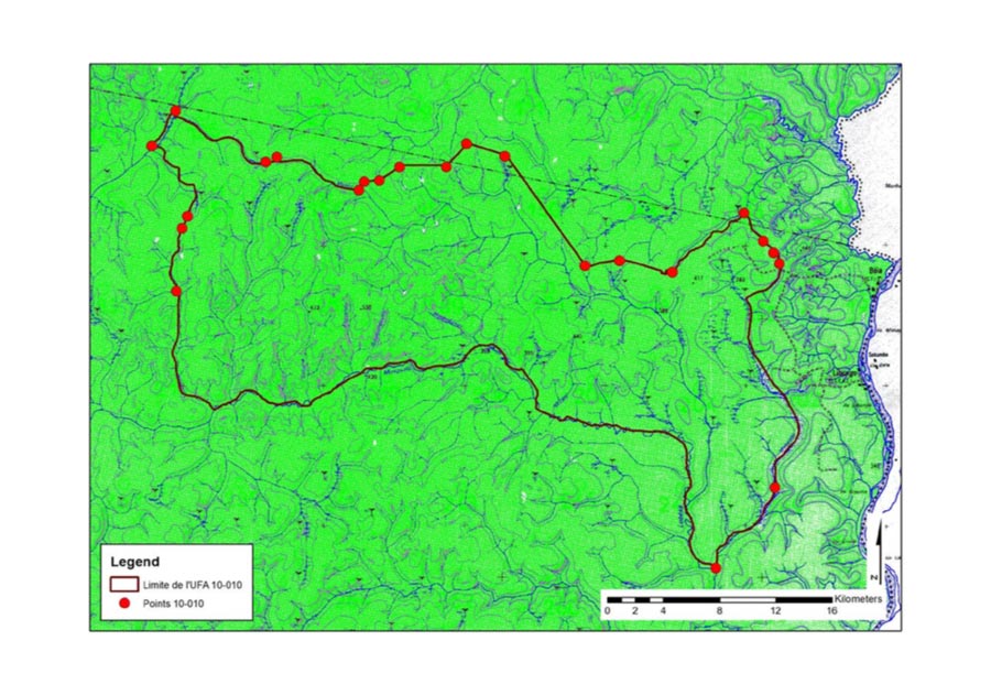
Figure 2 – Geographical situation and boundaries of UFA 10-010.
Ecological factors
Topography
The forest comprised in 10-010 mainly lies on lateritic soils. There are major variations due to the topography. They mainly relate to the humus-bearing horizon, which is greater in the non-marshy lowlands than at higher altitude. However, these forest soils are believed to be rich in organic matter, because the abundant forest litter can be converted to humus by the mineralisation and humification process. Paradoxically, they are mineral-poor due to rainwater infiltration, which drains the mineral elements to the lower horizons, thus making them unavailable to plants as a result of leaching.
Pedology
The forest comprised in 10-010 mainly lies on lateritic soils. There are major variations due to the topography. They mainly relate to the humus-bearing horizon, which is greater in the non-marshy lowlands than at higher altitude. However, these forest soils are believed to be rich in organic matter, because the abundant forest litter can be converted to humus by the mineralisation and humification process. Paradoxically, they are mineral-poor due to rainwater infiltration, which drains the mineral elements to the lower horizons, thus making them unavailable to plants as a result of leaching.
Hydrography
The hydrographic network of the study area is relatively dense, and belongs to the Congo Basin. The major watercourses include the tributary of the River Lokomo and the Goboumo watercourse. They form natural boundaries to the east and west. This forest is watered by several small streams which are tributaries of the Goboumo watercourse.
These streams are teeming with fish, including the following species: catfish (Clarias gariepinus), carp (Lutjanus sp and Sarotherodon sp), goldfish (Hemichromis guttatus), pike (Hepsetus odoe), electric catfish (Malepterurus electricus), fish belonging to the Schilbe genus, etc.