

Administrative information
The forest to which the present management plan relates is Forestry Management Unit (UFA) no. 10-009. In administrative terms, it is located in the East Province, Boumba and Ngoko Département. More specifically, it lies in two arrondissements, Yokadouma and Moloundou, especially in Salapoumbé District.
Definition of boundaries and geographical location
Forestry Management Unit no. 10-009 lies between latitudes 2°40’ and 3°20’ North and longitudes 15°40’ and 16°15’ East (Figure 1).
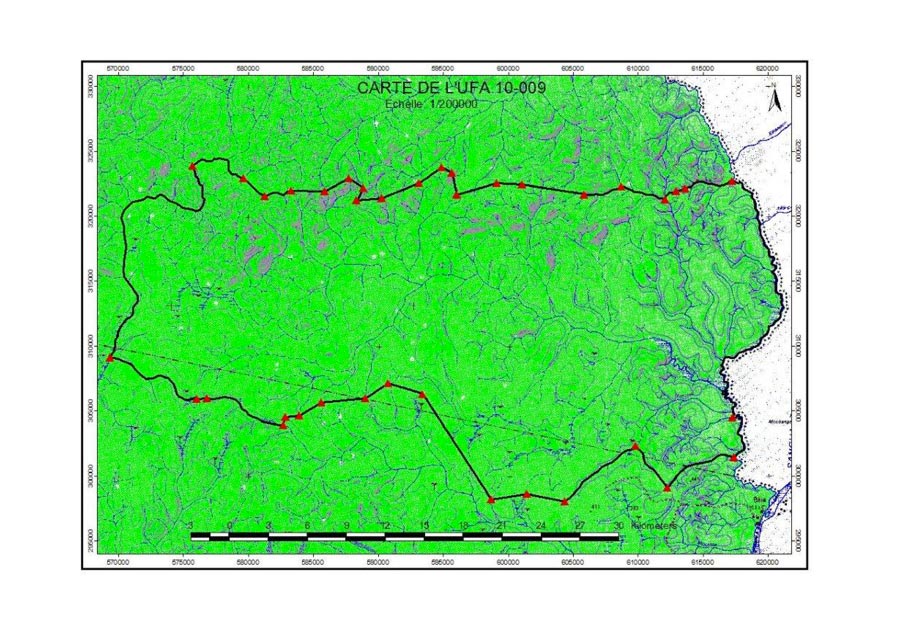
Figure 1 – Map showing location of UFA 10-009
Its boundaries are not yet definitive, but were proposed at the time of classification, when they were described as follows (Figure 2):
- Reference point R is located at the confluence of the River Sangha and the River Goboumo;
- From point R, follow the River Goboumo upstream for 7.6 km to reach point A, called the base point, located at the confluence of the River Goboumo and an unnamed tributary.
To the south:
- From point A, called the base point, follow the unnamed tributary upstream for 6 km to reach point B, located at a spring, equivalent to point A of UFA 10-010;
- From point B, follow a bearing of 321° for 1 km to reach point C, located at the source of an unnamed spring, equivalent to point B of UFA 10-010;
- From point C, follow that watercourse downstream for 3.2 km to reach point D, located at a spring, equivalent to point C of UFA 10-010;
- From point C, follow the other branch of the same watercourse upstream for 7.2 km to reach point D, located at a spring, equivalent to point C’ of UFA 10-010;
- From point D, follow a bearing of 286° for 3.2 km to reach point E, equivalent to point D of UFA 10-010;
- From point E, follow a bearing of 261° for 2.6 km to reach point F, equivalent to point E of UFA 10-010;
- From point F, follow a bearing of 324° for 9.7 km to reach point G, equivalent to point F of UFA 10-010;
- From point G, follow a bearing of 288° for 2.9 km to reach point H, equivalent to point G of UFA 10-010;
- From point H, follow a bearing of 224° for 2.1 km to reach point I, equivalent to point H of UFA 10-010;
- From point I, follow a bearing of 270° for 3.2 km to reach point J, equivalent to point I of UFA 10-010;
- From point J, follow a bearing of 236° for 1.7 km to reach point K, equivalent to point J of UFA 10-010;
- From point K, follow a bearing of 271° for 1.3 km to reach point L, located on a branch of the Moabo watercourse, equivalent to point K of UFA 10-010;
- From point L, follow that branch downstream for 0.7 km to reach point L’, located at the confluence of that branch and the Moabo watercourse, equivalent to point K’ of UFA 10-010;
- From point L’, follow the Moabo watercourse upstream for 6.7 km to reach point M, located at a small confluence, equivalent to point L of UFA 10-010;
- From point M, follow a bearing of 270° for 0.7 km to reach point N, located at the source of an unnamed spring, equivalent to point M of UFA 10-010;
- From point N, follow that unnamed watercourse downstream for 8.4 km to reach point O, located at the confluence of that watercourse and an unnamed tributary of the Lokomo, equivalent to point N of UFA 10-007 and point N of UFA 10-010.
To the west:
- • From point O, follow an unnamed tributary of the Lokomo upstream for 26 km to reach point P, located at the confluence of that tributary and an unnamed watercourse, equivalent to point O of UFA 10-007 and point Q of UFA 10-008.
To the north:
- From point P, follow the unnamed watercourse upstream for 6.7 km to reach point Q, located at a small confluence, equivalent to point P of UFA 10-008;
- From point Q, follow a bearing of 95° for 2.6 km to reach point S, equivalent to point O of UFA 10-008;
- From point S, follow a bearing of 58° for 2 km to reach point T, equivalent to point N of UFA 10-008;
- From point U, follow a bearing of 122º for 1.4 km to reach point V, equivalent to point L of UFA 10-008;
- From point V, follow a bearing of 84° for 1.9 km to reach point W, equivalent to point K of UFA 10-008;
- From point W, follow a bearing of 68° for 3 km to reach point X, equivalent to point J of UFA 10-008;
- From point X, follow a bearing of 55° for 2 km to reach point Y, equivalent to point I of UFA 10-008;
- From point Y, follow a bearing of 115° for 0.8 km to reach point Z, equivalent to point H of UFA 10-008;
- From point Z, follow a bearing of 168° for 1.7 km to reach point A1, equivalent to point G of UFA 10-008;
- From point A1, follow a bearing of 73° for 3.2 km to reach point A2, equivalent to point F of UFA 10-008;
- From point A2, follow a bearing of 94° for 1.9 km to reach point A3, equivalent to point E of UFA 10-008;
- From point A3, follow a bearing of 98° for 4.8 km to reach point A4, equivalent to point D of UFA 10-008;
- From point A4, follow an unnamed watercourse downstream for 7.5 km to reach point A5, located at a confluence, equivalent to point C of UFA 10-008;
- From point A5, follow the branch upstream northwards then eastwards for 1.5 km to reach point A6, located at a spring, equivalent to point C of UFA 10-008;
- From point A6, follow a bearing of 81° for 0.5 km to reach point A7, located at a source of a tributary of the River Goboumo, [then] for 4.5 km to reach point A8, located at the confluence of that tributary and the River Goboumo, at the level of the international border, equivalent to point A of UFA 10-008;
- From point A8, follow the River Goboumo downstream for 32 km along the border to return to point A, called the base point.
Ecological factors
Topography
The area in which UFA 10-009 is located is not particularly hilly. The landscape is that of a peneplain with hills in some places. The altitude ranges between 300 metres and a maximum height of 500 metres.
Pedology
According to the Yangambi classification (1956), UFA 10-009 belongs to the Cameroon-Congo domain of dense humid African forest. The Gabon-Congo or Cameroon-Congo forest comprises three districts (umbrophilic, mesophilic and periforest). This UFA belongs to the umbrophilic district, and especially, according to Letouzey, to the Congo forest. It is a dense humid semi-deciduous forest.
This forest contains several plant formations (layers), some of them on dry land and others on hydromorphic soils which are more or less disturbed.
Hydrography
The hydrographic network of the forest in our study area belongs to the Congo Basin, and is very extensive. It includes several watercourses with a bed exceeding several metres in width. The watercourses that serve the forest include the Loupoundji, Monpougné, Goboumo, Etoundi and Moabo watercourses, which are actually tributaries of the River Sangha.