

Administrative information
Logging concession no. 1052 is located on permanent State forestry land. It consists of Forestry Management Unit (UFA) no. 10-008, allocated to SEFAC by Logging Agreement no. 0836/CPE/MINEF/CAB dated 4 October 2001, and located in the East province, Boumba and Ngoko Departement, specifically in Yokadouma Arrondissement, Bidjouki canton.
Definition of boundaries and geographical location
UFA 10-008 is located between latitudes 2°54′ and 3°12′ North and longitudes 15°39’ and 16°03’ East.
It is shown on topographical maps NA-33-XXII (Yokadouma) and NA-33-XVI (Moloundou), scale 1:200,000 (Figure 1).
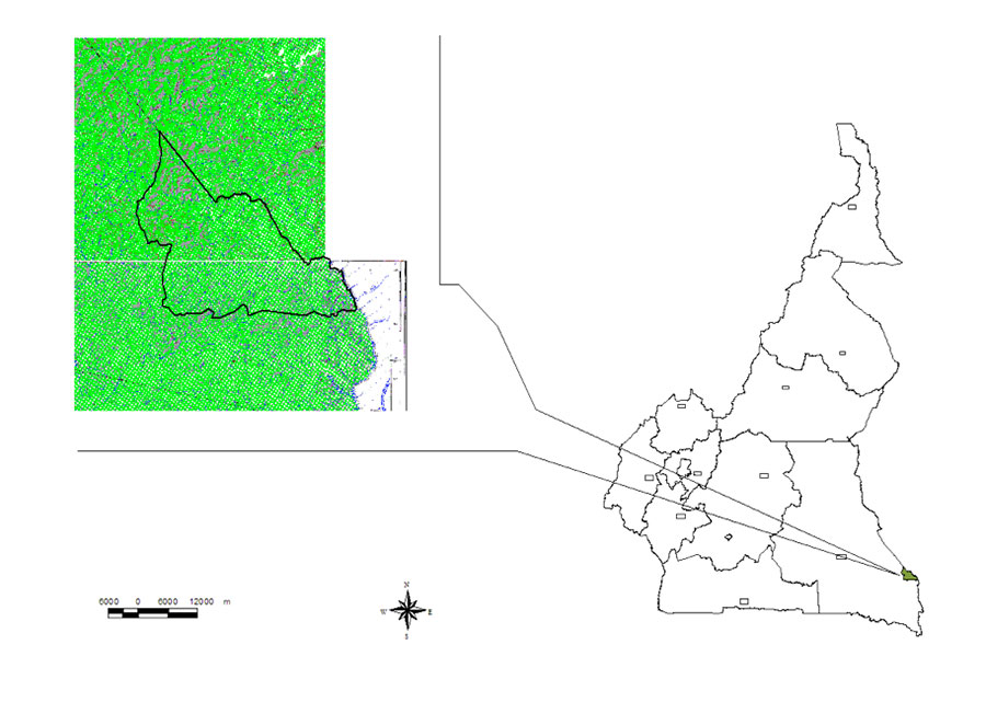
Figure 1 – Map showing location of UFA 10-008.
The description of the boundaries of this UFA (Figure 2) is taken from the Area Measurement Certificate drawn up by the Land Registry Office of BOUMBA AND NGOKO Département on 9 February 2001. According to that description, reference point R is located at the confluence of the River SANGHA and the River Goboumo.
- From point R, first follow the course of the River Goboumo upstream for 7.6 km to reach the confluence of the R.
Goboumo and an unnamed tributary, equivalent to point A of UFA 10-009.
Then follow this unnamed tributary upstream for 6 Km to reach point A, called the base point, located at a spring, equivalent to point B of UFA 10-009;
To the north:
- From point A, follow a bearing of 321 degrees for 1 km to reach point B located at the source of an unnamed watercourse, equivalent to point C of UFA 10-009;
- From point B, follow that watercourse downstream for 3.2 km to reach point B’, located at a confluence, equivalent to point C’ of UFA n degrees 10-009;
- From point B’, follow the other branch of the same watercourse upstream for 7.2 km to reach point C, located at a spring, equivalent to point D of UFA 10-009;
- From point C, follow a bearing of 286 degrees for 3.2 km to reach point D, equivalent to point E of UFA 10-009;
- From point D, follow a bearing of 261 degrees for 2.6 km to reach point E, equivalent to point F of UFA 10-009;
- From point E, follow a bearing of 324 degrees for 9.7 km to reach point F, equivalent to point G of UFA 10-009;
- From point F, follow a bearing of 288 degrees for 2.9 km to reach point G, equivalent to point H of UFA n degrees 10-009;
- From point G, follow a bearing of 224 degrees for 2.1 km to reach point H, equivalent to point I of UFA 10-009;
- From point H, follow a bearing of 270 degrees for 3.2 km to reach point I, equivalent to point J of UFA 10-009;
- From point I, follow a bearing of 236 degrees for 1.7 km to reach point J, equivalent to point K of UFA 10-009;
- From point J, follow a bearing of 271 degrees for 103 km to reach point K, located on a branch of the Moabo watercourse, equivalent to point L of UFA n degrees 10-009;
- From point K’, follow the Moabo watercourse upstream for 0.7 km to reach point L, located at a confluence, equivalent to point M of UFA 10-010;
- From point L, follow a bearing of 270 degrees for 0.7 km to reach point M, located at the source of an unnamed watercourse, equivalent to point N of UFA 10-009;
- From point M, follow that unnamed watercourse downstream for 8.4 Km to reach point N, located at the confluence of that watercourse and an unnamed tributary of the Lokomo, equivalent to point O of UFA 10-009 and point N of UFA 10-007.
To the west:
- From point N, follow the unnamed tributary of the Lokomo downstream for 3 km to reach point O, located at the confluence of that tributary and an unnamed watercourse, equivalent to point M of UFA 10-007;
- From point A, follow the unnamed watercourse upstream for 7.3 km to reach point P, located at a spring, equivalent to the SL of UFA 10-007;
- From point P, follow a bearing of 208 degrees for 0.9 km to reach point Q, located at the source of an unnamed watercourse, equivalent to point K of UFA 10-007;
- From point Q, follow that unnamed watercourse downstream for 4.8 km to reach point S, located at the confluence of that watercourse and an unnamed tributary of the Monguélé watercourse, equivalent to point P of UFA 10-011 and point H of UFA 10-012.
To the south:
- From point T, follow the Monguélé watercourse downstream for 62 km to reach point U, located at the confluence of the Lobéké and Mokalabo rivers, equivalent to point H of UFA 10-012;
- From point U, follow the River Mokalabo upstream for 7.5 km to reach point V, located at the confluence of the R. Mokalabo and a unnamed watercourse, equivalent to point I of UFA 10-012.
To the east:
- From point V, follow the River Mokalabo upstream for 20 km to reach point W located at a spring;
- From point W, follow a bearing of 349 degrees for 1.1 km to return to point A, called the base point.
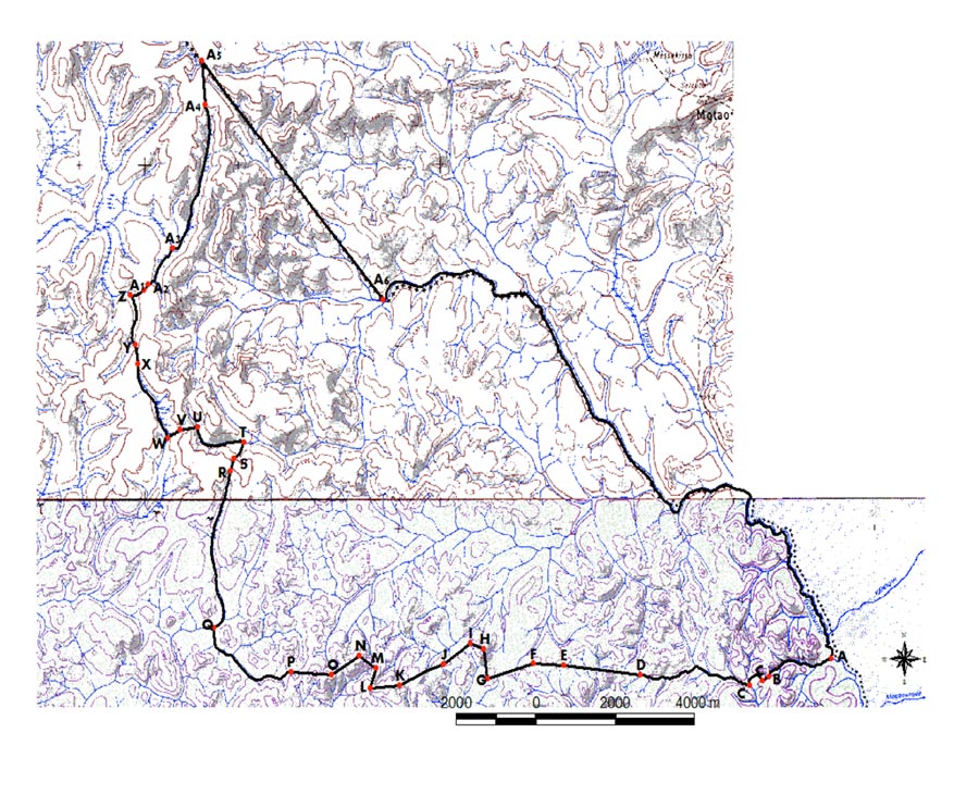
Figure 2 – Geographical situation and boundaries of UFA 10-008
Ecological factors
Topography
According to the topographical map of the area, the terrain is fairly even, with an average altitude ranging between 375 and 650 metres. However, some slopes are encountered which are generally steep and sometimes inaccessible, especially to the south-east of the UFA. A hollow in the slopes often indicates the presence of a torrent that dries up during the dry season.
Pedology
The area covered by UFA 10-008 basically consists of lateritic soils. These soils are generally nutrient-poor, acidic and fragile. The most widespread soils are orthic, mainly covered with forest. They are sometimes several metres thick, and are red, clayey, porous, loose and permeable, with little humus; this is the result of high, rapid mineralisation of the forest litter.
The “aliatic” soils are differentiated by a very fine phaneric structure.
Hydrography
The hydrographic network of the study area is relatively dense, and belongs to the Congo Basin. The major watercourses are the tributary of the River Lokomo and the Goboumo watercourse. They form the natural eastern and western boundaries of the UFA. This forest is watered by several small streams which are tributaries of the Goboumo watercourse.